Moving a Mace missile by the BACK roads to Grünstadt ©
By Fred Horky
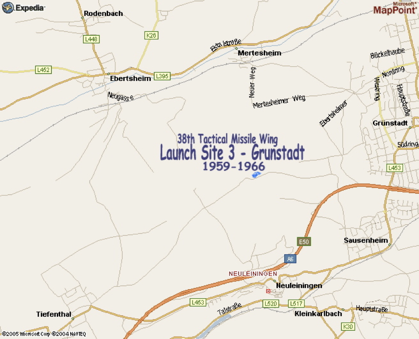
In 1959, “C” Flight was the 3rd and last element of the first TM-76A “Mace” squadron to deploy the new missile from its training base at Orlando, Florida to its first operational base at Sembach Air Base, Germany. Being last, its assigned launch site was the farthest away, twenty miles east at an abandoned former Security Service intelligence listening post “up on the hill” overlooking the Rhine River valley behind Grünstadt.
The normal and easiest route to move missiles to and from Grünstadt was the A6 autobahn. But the considerable distance from home base also made it a potentially vulnerable route, so an alternative route was sought. Thus very soon after my arrival in the summer of 1959, I was assigned the special project of proving the feasibility of moving a Mace via highway L395 through the villages of Enkenbach-Alsenborn, Ramsen, Eisenberg, and Ebertsheim. At Mertesheim, the test route would turn, climb up through the village on the north side of Grunstadterberg and on up to the launch site. (Tiny Mertesheim is not shown on this first map of the entire route, it is on the second map.)
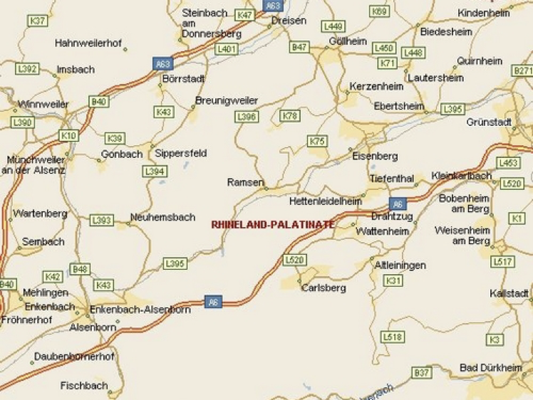
On this map, Sembach (and Sembach Air Base) is at far lower left; Grünstadt (and the Launch Site) at the far right
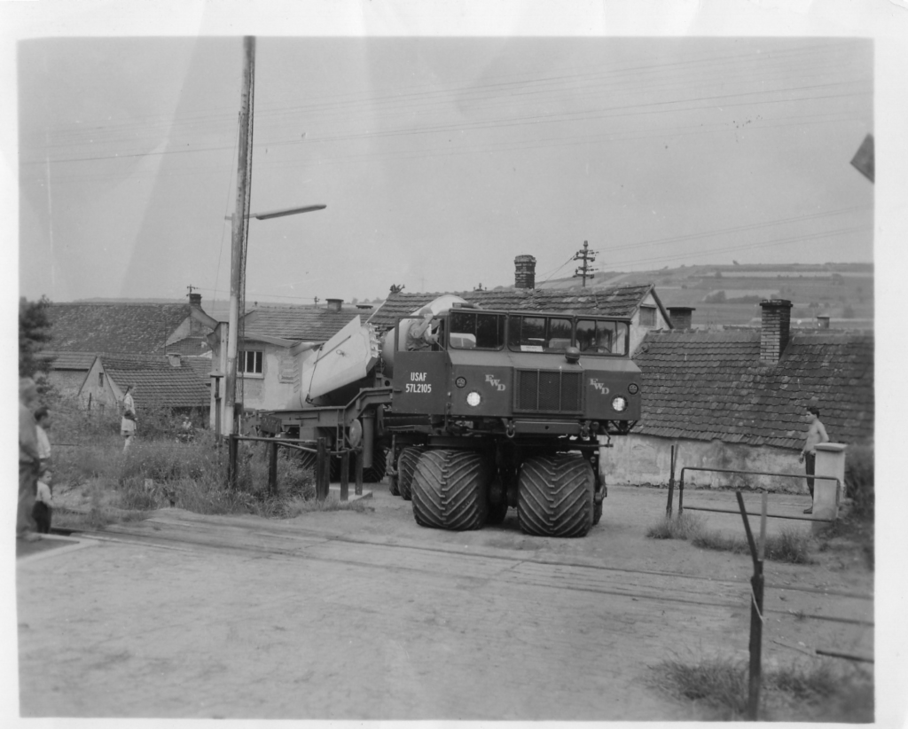
The test demonstrated that was it was possible, just barely, to move a Mace (much larger than the later GLCM (“ground launched cruise missiles”) and its huge translauncher, all towed by a big MM1 prime mover truck to the site via those narrow old roads. To my knowledge, nobody ever did it again. The specialist MM1 was unique to the Mace missile system, never ever receiving a standard “M-series” designation. To get an idea of its size, the next picture shows two of the four for which I was responsible as part of a property account “owned” in my additional duty as site supply officer. They’re parked on either side of my own Karmann-Ghia convertible.
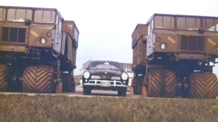
(The “Ghia” was a wanna-be sports car: the ultimate “sheep in wolf’s clothes”. With a pretty sporty-car body designed by Ghia, the famous Italian carrozzieri auto design specialist, and built by German coach-builder, Karmann: the result was assembled onto the plain-vanilla chassis of the Volkswagen “Beetle” ….complete with the VW’s anemic, air-cooled, four-banger engine …and its reliability! While admittedly only “sporty-looking”, the real advantage of the pretty little car over authentic sports cars of the era ….temperamental British MG’s, Triumphs, etc., …was that, like the Beetle it came from, the Ghia would just run and run and then run some more, with no problems!)
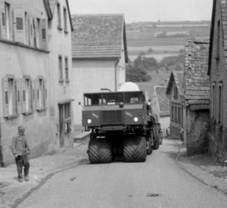
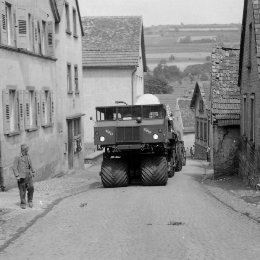
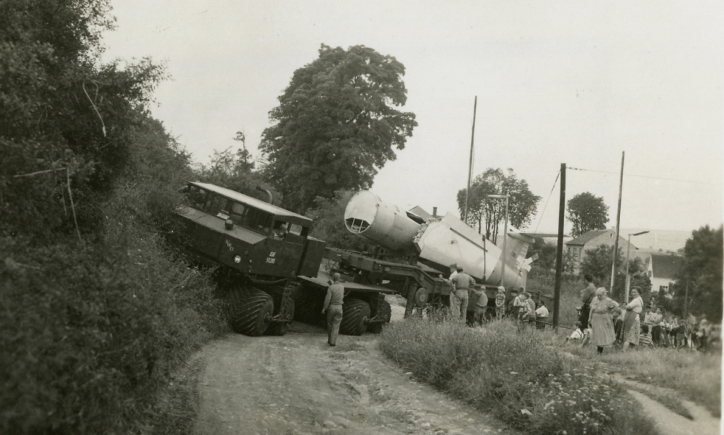
A base photographer had been sent with us to document difficult parts of the route, show “tight spots” and other item of interest on the route. Some were quite dramatic.
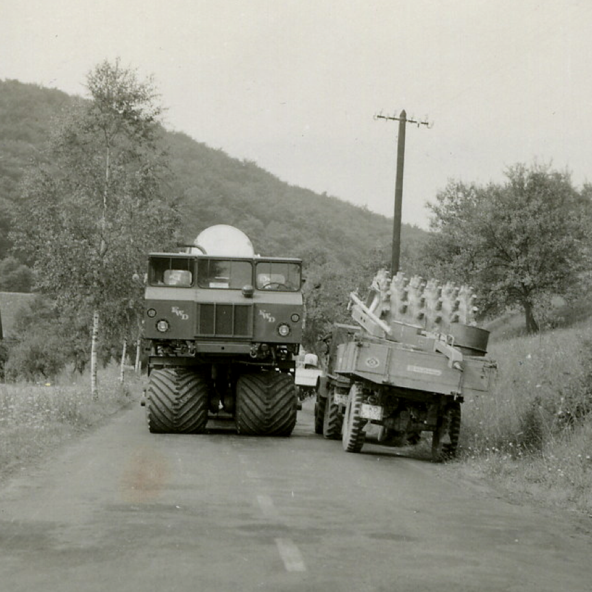
At many locations in those rural villages, old and very substantial houses were built to the very edge of both sides of very narrow streets. Nominally they were “two-way”, but that was for Volkswagens, not MM1’s! The convoy took the entire road, curb to curb!
Old memories tell me the above picture was taken in the town of Ramsen, in a place where the nominally two-lane highway narrowed so that the MM1, prime mover, translauncher, and missile absolutely filled the road from gutter to gutter; only inches away from the very substantial masonry houses on either side. Shown is a plump German hausfrau, doing her typically-German daily sweeping of her front steps, looking up to gape in amazement at Der Amerikaner Raketen bearing down on her….
Fortunately, we did have a Landespolizei (German state police) unit helping us with traffic, not that I recall anyone contesting the right of way with the missile.
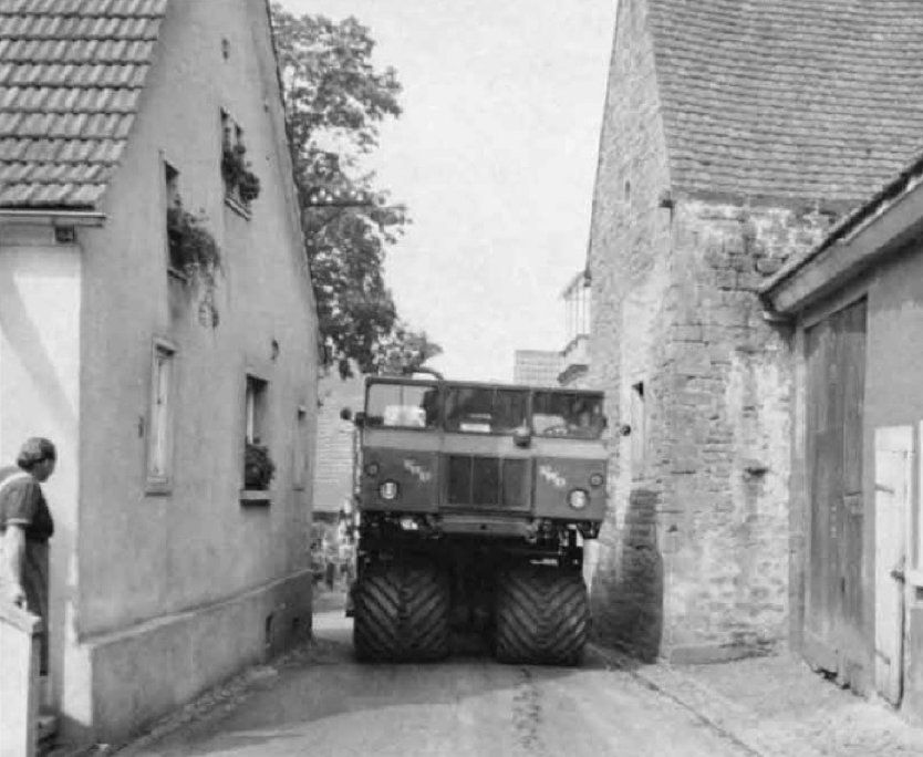
At tiny Mertesheim (pop. 400, but now celebrating its 1,250th year!) we left the highway to climb Grunstadterberg (the hill) to the launch site. Shown next is the MM1 and the Mace on its transporter/launcher climbing up through the village main street: the steep gradient of the climb from the valley is evident.
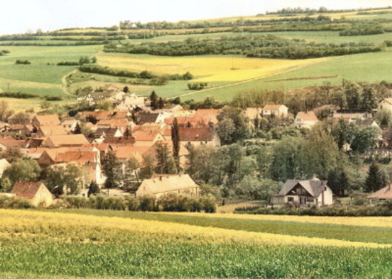
Mertesheim is seen again above, viewed from the opposite side of the valley in an image scanned from a color postcard. Our launch site is out of sight at the top of the hill. In between, a railroad track was located immediately at the far (uphill) edge of the village; in the picture located along the horizontal line of hedges. Only unpaved farmer lanes went from there up to our launch site.
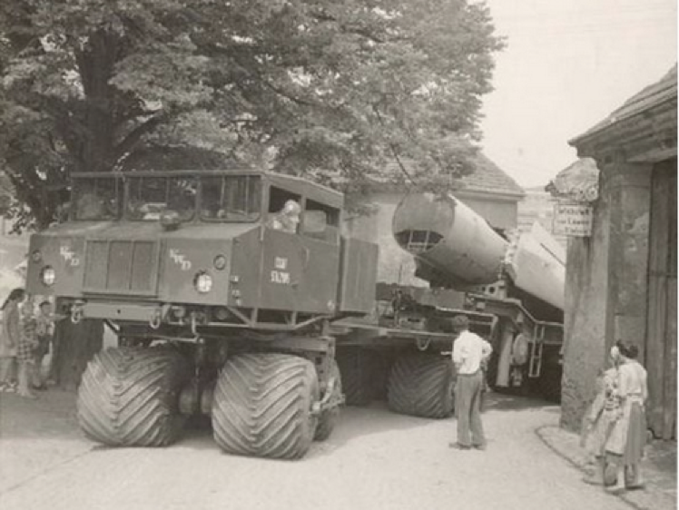
Just at the upper end of Mertesheim’s main street, a revered old Linden tree was in a position of honor in the middle of small “roundabout”. I learned much later (from a G.I. who had married a German girl from Mertesheim!) that the tree was considered sort of a good luck talisman for the village. Traffic was supposed to go around the old tree, but the MM1, translauncher, and missile couldn’t make that turn, so sort of went through the tree, as seen below. I don’t think we made any friends in Mertesheim.
Looking at the picture today came with the shock of realization that the little German boy at far left leaning on the Linden tree and wearing the traditional lederhosen (literally, “leather pants”) would today be well over sixty!
The next picture below was taken at the same location; the same little boy (like all little boys), probably much closer than his mother would like.
Just beyond the tree we had to take a very sharp RIGHT turn to cross the railroad tracks …they can be identified in the map below. Our destination, the 38th Tactical Missile Wing “Site 3”, also called “the Grunstadt site”, was now only about a half mile away. I’ve added it to the map as the tiny blue rectangle.
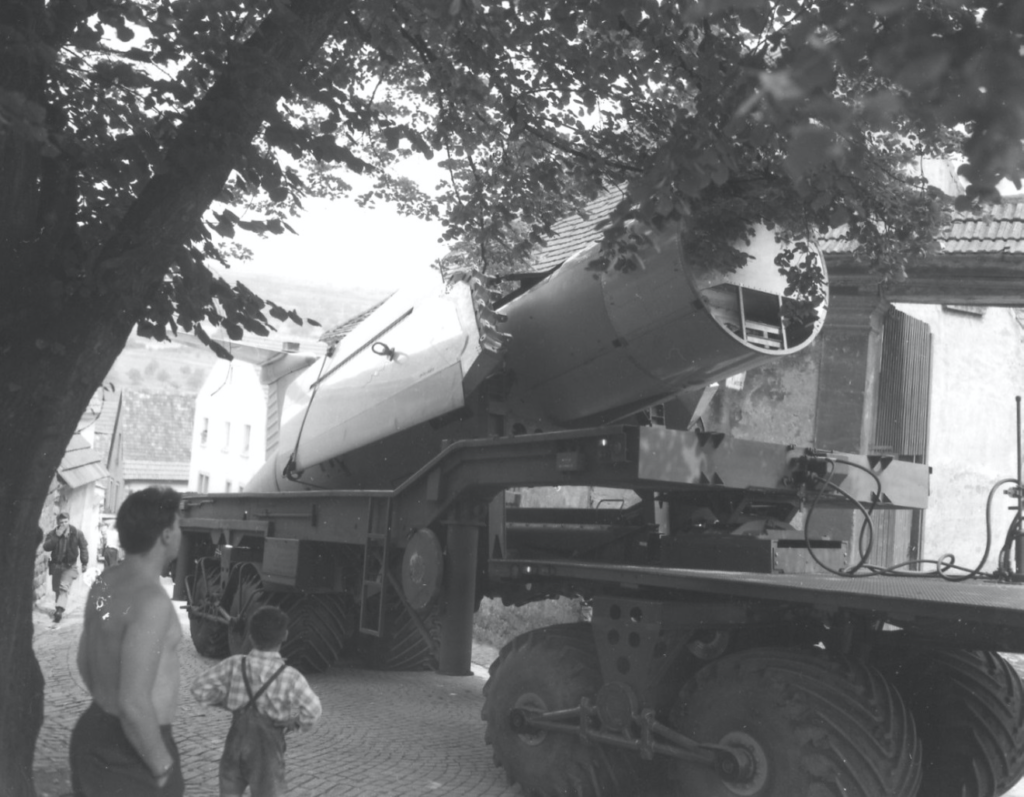
The next obstacle was a hard right turn across the railroad tracks, seen below….
The MM1, translauncher, and missile next had to negotiate an IMMEDIATE and even tighter LEFT turn, because of the hillside seen in the image below. The rear ends of the missile and launcher are not yet all the way across the railroad tracks!
It took several minutes of the driver shifting back and forth (naturally, with everyone “helping” by shouting conflicting directions!) to finally get his rather large apparatus across the railroad tracks.
And sure enough, no sooner than it was across the tracks, a train came through!
After crossing the railroad, the trip up the hill on unpaved tractor lanes to the missile site was easy. Of course, that was just the sort of terrain the MM1 prime mover had been built for. In fact, it could have gone about anywhere cross-country, though I’d hate to have had to sort through the resulting damage claims from German farmers….
The missile having safely arrived at the Grunstadt site, its return was via the autobahn!
After my report was written and submitted to the commander, the photographer gave me his negatives and extra prints, taken by his now very old fashioned, large format, black and white “Speed Graphic” professional camera. The best of those images, now digitized, have been retained for over sixty years!
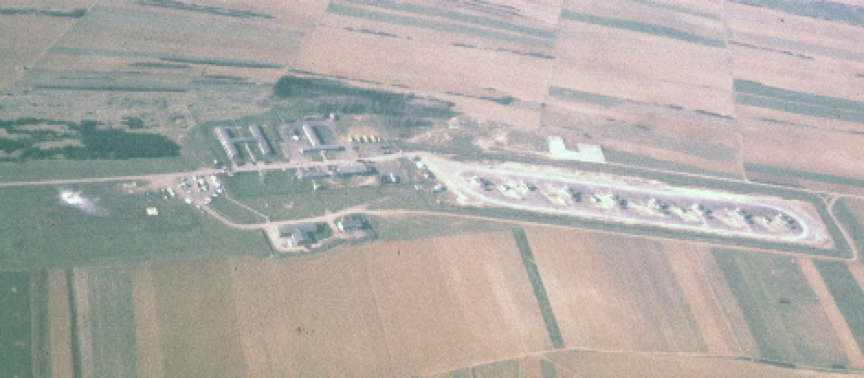
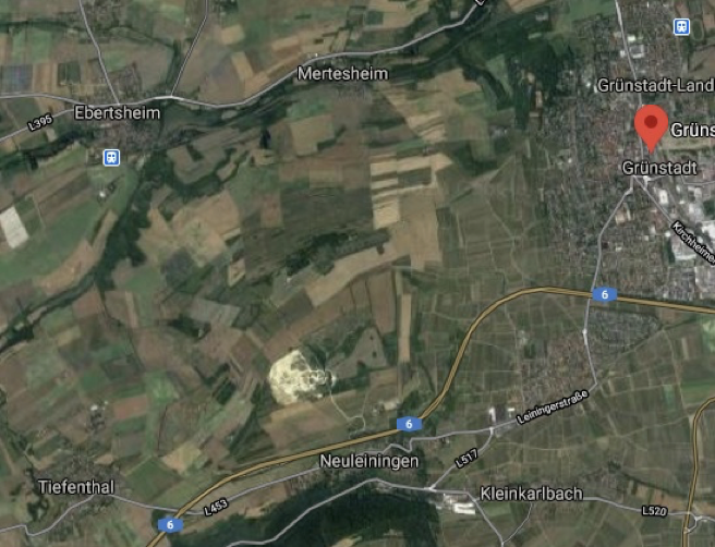
The present-day Google photo from space, below, shows the same general area today as the map above: the former launch site is in the exact center. The small grove of trees immediately north of the site is obvious; the outlines of the launch pads faintly visible.
That Google image can be compared to my aerial picture of the missile site in 1961, taken from the front seat of a T-33 jet that I was flying. The view is from about the same angle. ©